|
UNDER
CONSTRUCTION
|
A
bit further W, straddling the river, is Acharkut
(once Kunen), a formerly mixed village founded in 1930
as part of a forestry collective but occupying part of a once
major 9-10th c. town site.
On the N bank is an early church. On the slope S of Acharkut by the bridge, a dirt road
winds uphill to a ramshackle cemetery church
of S. Astvatsatsin (inscription reads: “In
the year 1675 I |
|
Bumping
back to the main road, you cross imperceptibly into a projecting
piece of Azerbaijan and the destroyed Azeri village of Lower
Askipara. However, the de facto boundary in 1999 runs along a
line of hills about 3 km further E. The spur road left takes one back into
Armenia, the
village of Voskepar
just W of the
road. Still standing on the edge of
the ruins of |
UNDER
CONSTRUCTION
|
|
Melikshahnazar son of Melikaslamaz of
the Herume
clan, and my wife Khanzate built S. Astvatsatsin by the hand of
Master Hakop.”) and a picnic area beyond. At the W edge
of Acharkut, on the N side of the stream (medieval Sranots
bridge somewhere nearby), the main village road ends at a locked
gate, which a neighbor will open. About 1 km W of the gate, overlooking the muddy, rutted
but passable track (ideal for mountain bikes), are the ruined
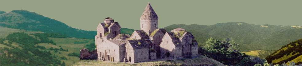
but interesting remains of a caravansaray below the 13th
c. Arakelots
(Apostles’) Monastery complex. About 80 m further, a jeep track branches uphill to the
monastery proper, visible on the crest of the hill in dense
forest. Though the
church is unimpressive, the forest setting, the mossy tombstones
and substantial remains of the defensive circuit make this a
rewarding site. A worn inscription of 1293 over the S entrance to the gavit
links the site to Khutlu Bugha Artsruni, son of Atabek Sadun,
lord of Mahkanaberd in the 13th c. In return for helping Vakhtang mount the throne of
Georgia, Khutlu Bugha was made atabek
and amirspasalar of Georgia. Unfortunately,
a change of Mongol Il-Khans left him on the wrong side, and he
was put to death in 1297 for plotting insurrection. There is a ruined chapel on the next hill as well. Supposedly, 2 km NE of Arakelots Vank on a flat place on
the mountain ridge is the little church and khachkar of
Khndzorut.
To
reach the remote but unique 13th-14th c. Kirants
Monastery, continue upstream. After another 5 km or so, one branch of the road turns
left, crossing the Zayghoshani bridge (with Persian inscription: in the year of the Hijra 1207-AD 1792) and ascending S
toward Deghdznuti
Vank of the 13th c. (1 km or so). The small but fine main church seems to have been begun
in 1258 and finished in 1274, and the gavit built very soon
afterwards. An
inscription on the S arch of the gavit remembers Asil, a pilgrim
of 1292 from Mesopotamia, probably an Armenian merchant who did
well in difficult times. Another
6 km S of Deghdznuti (and probably more reachable from Yenokavan)
is Samsoni Vank. This latter monastery has a domed 12-13th c.
church, a shrine and another small church.
On the right bank of the Khndzorkut river, atop a
mountain between Deghdznuti and Samsoni Vank is supposed to be
the Berdakar medieval fort, with cisterns. This would
have been Mahkanaberd,
the fortress-capital of the Artsruni family, who enjoyed
quasi-autonomy in the area in the 11-13th c. On
a slope opposite Deghdznuti Vank are allegedly remains of
another fort, Melik-Abovi Berd. Back
along the main river track, at about 8 km from the gate on the
main W track is a splendid modern local monument, a monumental
stone-built picnic site with open-air museum above a rock overhang closed with an iron
grating, with local agricultural and household implements from
the 19th c. Continuing
upstream, dodging rocks and deep ruts, one finally sees
at about 10 km Kirants
Monastery, 13-14th c. The well-preserved but disused main church is unusual for
its brick construction and elegant colored tile decoration.
|
|
Askipara,
intact/restored despite use in the fighting as a machine gun
nest, is Astvatsatsin
Church of the 7th c.
Somewhere near are traces of a 10-11th c.
castle. A deteriorating road W from Voskepar leads one to a
lovely stream valley filled with the skeletal houses of Upper
Askipara (Verin Aghsibara), separated from Lower Askipara
by Voskepar. At the W end of the village is an 18th (?) c.
tower fort with arrow slits. One km beyond is a medieval stone bridge.
Taking the road further upstream, the right fork may lead
to a large ruined church beyond the old collective farm complex. |